
 Published by
West Tennessee
Industrial Association
Crockett County Toolkit
A site-selection and RFI-ready data toolkit for Crockett County, Tennessee — population, workforce and labor shed, available industrial sites, logistics, and economic indicators, with every figure linked to its published source.
Community Snapshot
Demographics
| Population (Esri 2025) | 13,896 |
| Annual population growth (Esri) | -0.02% |
| Average household size | 2.46 |
| Median age | 41.9 |
| Median household income (ACS 2020–24) | $62,165 |
| Median household income (Esri 2025 est.) | $65,002 |
| Median home value | $154,664 |
| Median net worth | $180,712 |
| Diversity index | 56.5 |
Source: WTIA / Esri Community Summary, Crockett County (Esri 2025; ACS 2019–2023; prepared by WTIA, Mar 18, 2026). Median household income (ACS): U.S. Census Bureau ACS 2020–24 5-year estimate (table B19013); Tennessee $69,595.
Age profile (Esri 2025)
Workforce by occupation type
Home ownership: 72.5% own · 27.5% rent.
Communities
Alamo
- Population
- 2,354 (Census V2025)
- Median age
- 40.8
- Median HH income
- $51,689
- Median home value
- $137,613
Bells
- Population
- 2,473 (Census V2025)
- Median age
- 37.2
- Median HH income
- $58,929
- Median home value
- $140,972
Friendship
- Population
- 618 (Census V2025)
- Median age
- 39.7
- Median HH income
- $45,243
- Median home value
- $105,000
Community figures: Esri 2022 estimates (ACS 2017–2021) from WTIA community profiles, © 2023 Esri — older vintage than the county figures above. Data sheets via West Tennessee Industrial Association.
Labor Shed
Crockett County and the five surrounding counties in the WTIA labor shed hold a combined labor force of 110,563 (August) and produced 2,182 high school graduates in 2023–2024.
| County | 2025 Population | 2023–2024 HS Graduates | August Labor Force | August Unemployed | August Unemployment Rate |
|---|---|---|---|---|---|
| Crockett | 14,006 | 184 | 6,432 | 211 | 3.3% |
| Dyer | 36,320 | 351 | 17,995 | 608 | 3.4% |
| Gibson | 51,779 | 574 | 21,907 | 875 | 4.0% |
| Haywood | 17,042 | 176 | 9,824 | 340 | 3.5% |
| Lauderdale | 24,617 | 234 | 9,031 | 435 | 4.8% |
| Madison | 100,790 | 663 | 45,374 | 1,947 | 4.3% |
| Labor shed total* | 244,554 | 2,182 | 110,563 | 4,416 | 4.0% |
Source: West Tennessee Industrial Association — Labor Shed Data table (labor force and unemployment: BLS LAUS, Aug 2026, preliminary). Population: U.S. Census Bureau Vintage 2025 (Jul 1, 2025). *Totals and the combined rate are calculated here by summing the six counties as published (unemployed ÷ labor force).
August labor force by county
August unemployment rate
Commuting patterns — Crockett County, 2023 (all jobs)
- Jobs located in county
- 4,031
- Filled by in-commuters
- 2,319 (57.5%)
- Workers living in county
- 6,005
- Out-commuting residents
- 4,293 (71.5%)
- Live & work in county
- 1,712
4,293 residents leave the county for work each day — a potential recruitment pool for new local employers.
Source: WTIA Crockett County Worker Flow.
Sites & Buildings
Five industrial sites totaling 213.6 acres are listed on the WTIA GIS portal for Crockett County, in Alamo, Bells, and Friendship. Every site is served by Gibson Electric Membership Corporation, and every one but Emerson sits adjacent to U.S. Highway 412.
| Site | City | Acres | Sale price | Highway access | To I-40 | Rail at site | Details |
|---|---|---|---|---|---|---|---|
| Emerson Site Highway 70/79A | Bells | 23 | Not listed | U.S. Highway 70 (adjacent) | 20 mi | Not stated | WTIA listing Spec sheet (PDF) |
| Crockett County Industrial Park 9100 Highway 412 | Friendship | 40 | $15,000/acre | U.S. Highway 412 (adjacent) | 28 mi | Not stated | WTIA listing Spec sheet (PDF) |
| Kail Property 1300 Egg Hill Road | Alamo | 87.6 | Not listed | U.S. Highway 412 (adjacent) | 18 mi | Not stated | WTIA listing Spec sheet (PDF) |
| Highway 412 Industrial Site Highway 412 Industrial Site | Bells | 23 | Not listed | U.S. 412 (adjacent) | 15 mi | Not stated | WTIA listing Spec sheet (PDF) |
| Searcy Property London Road & Highway 412 | Alamo | 40 | Not listed | U.S. Highway 412 (adjacent) | Not stated | Not stated | WTIA listing |
| Total listed acreage | 213.6 | ||||||
Source: West Tennessee Industrial Association (site list); WTIA site detail pages (sites/id/12, 28, 29, 43, 106) (addresses, providers, port/airport miles). Acreage, price, on-site utility status, rail and I-40 miles: WTIA GIS portal (Oct 8, 2026). Older wtia.org listings showed 214 acres total and 88 acres for Kail; this toolkit uses the GIS portal values (213.6 and 87.6). Confirm availability and pricing with WTIA or the Crockett County Chamber.
Emerson Site
- Electric
- Gibson EMC — on-site
- Natural gas
- Bells Gas & Water — on-site
- Water
- Bells Gas & Water — on-site
- Wastewater
- City of Bells — not on-site
- Telecom
- AT&T — not on-site
- Port
- Port of Cates Landing · 63.3 mi
- Airport
- Memphis Int'l · 75.5 mi
Crockett County Industrial Park
- Electric
- Gibson EMC 3-phase, 25kV, 93A — on-site
- Natural gas
- City of Friendship (4" main) — on-site
- Water
- City of Friendship (10" main) — on-site
- Wastewater
- City of Friendship (8") — on-site
- Telecom
- AT&T, TEC, Aeneas, Jones Communications, IRIS Networks, ENA — on-site
- Port
- Port of Cates Landing · 49.6 mi
- Airport
- Memphis Int'l · 95 mi
Kail Property
- Electric
- Gibson EMC — on-site
- Natural gas
- Crockett County Public Utility District (2" main) — on-site
- Water
- City of Alamo (3" main) — on-site
- Wastewater
- City of Alamo — not on-site
- Telecom
- AT&T, TEC, Aeneas, Jones Communications, IRIS Networks, ENA (site sheet); fiber: yes (GIS portal)
- Port
- Port of Cates Landing · 56 mi
- Airport
- Memphis Int'l · 83 mi
Highway 412 Industrial Site
- Electric
- Gibson EMC — on-site
- Natural gas
- Bells Gas & Water — on-site
- Water
- City of Bells — on-site
- Wastewater
- City of Bells — on-site
- Telecom
- AT&T — on-site
- Port
- Port of Cates Landing · 63.3 mi
- Airport
- Memphis Int'l · 75.5 mi
Searcy Property
- Electric
- Gibson EMC — on-site
- Natural gas
- Crockett County Public Utility District — not on-site
- Water
- City of Alamo — not on-site
- Wastewater
- City of Alamo — not on-site
- Telecom
- AT&T — not on-site
- Port
- Port of Cates Landing · 56 mi
- Airport
- Memphis Int'l · 81 mi
Available buildings
No buildings are currently listed for Crockett County on the WTIA county page. For off-market or newly available buildings, contact WTIA (731.668.4300 · info@wtia.org) or the Crockett County Chamber ((731) 696-5120).
Transportation & Logistics
Highway & rail network
- U.S. Highway 412 crosses the county diagonally through Friendship, Alamo, and Bells. Four of the five listed sites are adjacent to it.
- Interstate access: The county map marks I-40 as 5 miles past the county line on the route toward Jackson, and I-155 as 10 miles past it toward Dyersburg. Listed sites are 15–28 miles from I-40, per WTIA site pages.
- U.S. 79 / U.S. 70-79A and State Routes 54, 88, 152, 188, and 221 connect to Humboldt, Trenton, Brownsville, and Jackson.
- CSX rail line runs through the Bells–Gadsden corridor (county map). Rail service at the five sites is not stated on the WTIA GIS portal.
- Port: Port of Cates Landing, 49.6–63.3 miles from the listed sites.
- Air: Memphis International Airport, 75.5–95 miles from the listed sites.
- General aviation: Humboldt Municipal (M53), 17 miles from Alamo, 4,003-ft runway; McKellar-Sipes Regional (MKL, Jackson), 25 miles, 6,007-ft runway (FAA).
- Drive distances from the town halls (Alamo, Bells, Friendship): Jackson 19–35 mi (26–45 min); Memphis 76–82 mi (1:33–1:53); Nashville 144–160 mi (2:40–2:59). Source: OSRM public router, Oct 21, 2026.
Source: WTIA Crockett County map; WTIA site detail pages (sites/id/12, 28, 29, 43, 106).
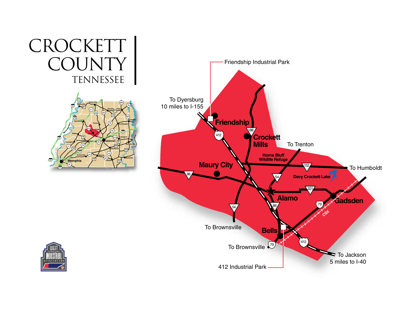
Map: WTIA Crockett County map.
Economy: Income & GDP
Property tax
Crockett County: $1.70 per $100 assessed value (2025; TN Comptroller). City rates per $100 (2025): Alamo 0.71 (total 2.41), Bells 0.94 (2.64), Friendship 1.4765 (3.1765), Maury City 0.6025 (2.3025); Gadsden has no listed city rate. Sales tax: 9.75% countywide (7% state + 2.75% local, TN Dept. of Revenue). Assessment ratios set by state law: industrial and commercial real property 40%, business personal property 30% (TN Comptroller). No special school districts are listed for Crockett County (2025 Tax Aggregate Report). Opportunity Zone: census tract 47033961100 (Alamo area) is the county's only OZ (TNECD 2018 list).
Per capita personal income, 2024
PCPI grew 3.5% in 2023–24 (TN 4.8%, US 4.6%). 2014–24 compound annual growth: 4.7% (TN 5.2%, US 4.7%). 2014 PCPI: $34,189.
Personal income growth, 2023–2024
2014–24 compound annual growth: Crockett 4.2%, TN 6.2%, US 5.4%. 2014 personal income: $496,839 thousand. 2014 GDP: $505,916 thousand; real GDP CAGR 2014–24: 1.3% (TN 3.1%).
Components of personal income — growth
| Component | Crockett 23–24 | TN 23–24 | US 23–24 | Crockett CAGR 14–24 | TN CAGR 14–24 | US CAGR 14–24 |
|---|---|---|---|---|---|---|
| Net earnings | 2.1% | 5.4% | 5.4% | 4.8% | 6.0% | 4.8% |
| Dividends, interest & rent | 2.0% | 5.5% | 4.9% | 3.1% | 7.6% | 6.5% |
| Personal current transfer receipts | 6.8% | 8.0% | 7.0% | 3.4% | 5.8% | 6.0% |
Source: WTIA BearFacts 2026 — U.S. Bureau of Economic Analysis Economic Profile for Crockett, published Feb 5, 2026. Dollar amounts are not adjusted for inflation. Services-producing industries made up the largest share of 2024 GDP, followed by goods-producing industries and government.
Downloads
Printable one-pagers for RFI responses, along with the WTIA source documents behind this toolkit. Site spec sheets are linked in the Sites table.
Crockett County Community Snapshot
KPIs, demographics, labor shed, sites, logistics, and Hitachi Energy, all on one printable page.
Sites & Labor Shed Detail
All five listed sites with utilities and distances, plus the six-county labor shed table and commuting flows.
Crockett County Community Summary (CrockettCP2026)
Esri/ACS demographics, income, housing, and occupations. Prepared by WTIA.
BearFacts 2026 — Economic Profiles
BEA personal income and GDP profiles for West Tennessee counties. Crockett's profile is the first in the document.
Crockett County Map
Highways, rail, communities, and the industrial park locations.
Crockett County Worker Flow
Inflow and outflow commuting counts for all jobs.
Alamo Community Profile
Town of Alamo data sheet.
Bells Community Profile
City of Bells data sheet.
Friendship Community Profile
City of Friendship data sheet.
Sources & Notes
- West Tennessee Industrial Association — Crockett County page
https://www.wtia.org/counties/id/6 - WTIA BearFacts 2026 — BEA Economic Profile for Crockett (personal income & GDP, published Feb 5, 2026)
https://www.wtia.org/images/uploads/content_files/BearFacts2026.pdf - WTIA / Esri Community Summary, Crockett County (Esri 2025; ACS 2019–2023; prepared by WTIA, Mar 18, 2026)
https://wtia.org/images/uploads/content_files/CrockettCP2026.pdf - WTIA Crockett County map
https://www.wtia.org/images/uploads/content_files/crockettmap.pdf - WTIA announcement — Hitachi Energy to Expand Manufacturing Operations in Crockett County (Aug 20, 2025)
https://www.wtia.org/announcements/hitachi-energy-to-expand-manufacturing-operations-in-crockett-county - Crockett County Chamber of Commerce
https://www.thecrockettchamber.net/ - WTIA Crockett County Worker Flow — U.S. Census Bureau OnTheMap / LEHD, 2023 (created Mar 18, 2026)
https://www.wtia.org/images/uploads/content_files/crockettworkerflow2026.pdf - WTIA community profiles — Alamo, Bells, Friendship (Esri 2022 estimates; ACS 2017–2021; © 2023 Esri)
https://www.wtia.org/counties/id/6 - WTIA site detail pages (sites/id/12, 28, 29, 43, 106)
wtia.org/sites/id/12 wtia.org/sites/id/28 wtia.org/sites/id/29 wtia.org/sites/id/43 wtia.org/sites/id/106 - U.S. Census Bureau — Vintage 2025 population estimates (county & city, Jul 1, 2025)
https://www.census.gov/programs-surveys/popest.html - BLS Local Area Unemployment Statistics (Aug 2026, preliminary) and QCEW 2025 annual
https://www.bls.gov/lau/ - TN Comptroller — 2025 property tax rates, assessment ratios and 2025 Tax Aggregate Report
https://comptroller.tn.gov/office-functions/pa/tax-resources/assessment-information-for-each-county/property-tax-rates/2025.html - TN Department of Revenue — local sales tax rates; UT CTAS county sales tax table
https://www.tn.gov/revenue.html - TNECD — Site Development Grant (Feb 4, 2026); Opportunity Zone list (Aug 7, 2018)
https://oz.tnecd.com/wp-content/uploads/2021/04/Tennessee-Opportunity-Zones-8-7-2018.pdf - WTIA GIS Property Portal — Crockett County sites (acreage, price, on-site utilities; Oct 8, 2026)
https://wtia.giswebtechguru.com/?sorting=featured&showpropertyonmap=true - Crockett County Government (County Mayor Joe Gibson) and WBBJ (Sep 1, 2026)
https://crockettcountytn.com/government - Utilities and training: Gibson EMC, Crockett County Public Utility District, TCAT Northwest
https://www.gibsoncoops.com/ - Drive distances: OSRM public router (Oct 21, 2026); runways: FAA airport records
https://router.project-osrm.org/